
Norwich ZIP Code Directory Coverage
The Secretary of the State’s post-office list gives Norwich, Taftville, and Yantic as postal identities used in the Norwich area. It also directs a street-level check through USPS. The table separates those delivery labels from Preston context, which can enter a boundary search but is not listed as a Norwich post office. The neighborhood names are useful clues, not a promise that every street or parcel follows the same line.
| ZIP | Areas Covered | Post Office | Notes |
|---|---|---|---|
| 06360 | Main Norwich, Downtown, Norwichtown, Occum, and much of the central city | Norwich | Verify the particular street with USPS |
| 06380 | Taftville and parts of the northern city | Taftville | Postal city associated with a Norwich neighborhood |
| 06389 | Yantic and nearby Norwich delivery area | Yantic | Postal city, not a separate municipality |
| 06365 | Preston post-office area adjoining Norwich | Preston | Neighboring postal context, not a Norwich post office |
The Connecticut post-office list is the source for the postal-city relationship. For formation and consolidation context, compare the Connecticut State Library town-and-county table with the postal label instead of treating either source as a municipal boundary map.
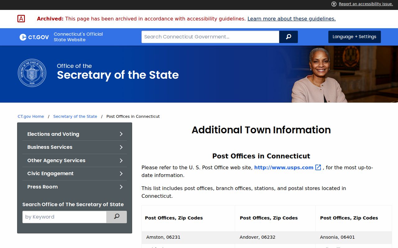
The image is a reference point for postal names, not a parcel map or person index. A current result still needs an address-level USPS check.
What 06360 Means in Norwich
06360 is the main Norwich postal label in the research set. It is associated with Downtown, Norwichtown, Occum, and much of the central city. Those terms also occur in planning, directory, map, and historic records, so a 06360 search can begin with postal geography and then move to a neighborhood or street name. A ZIP code is a delivery aid. It does not tell whether a name on a parcel card is an owner, a mailing agent, or a person at the address.
For a person question, use the ZIP only to narrow the address set. Confirm the situs parcel, compare the owner and mailing fields, and retain the date of the result. If a historic directory uses Norwich Town or a mill label, preserve that printed term rather than silently changing it to a modern postal city. The same street can be described differently across a directory, a USPS record, an assessment card, and a deed.
Taftville in Norwich Postal Geography
06380 is associated with Taftville and parts of the northern city. Taftville is a postal city label within the broader Norwich record story, not a reason to send a search to a separate municipal clerk. A directory or map may use Taftville because the area’s mill and neighborhood history supplied a strong local name. The postal field answers delivery routing, while the city and parcel fields answer municipal and property questions.
When a Taftville address is being checked, keep the street, ZIP, situs, parcel ID, and mailing address as separate fields. A person can be tied to a historic address, a business filing, a deed party, or a voter record without all those records using the same place label. The ZIP code directory helps normalize the first address clue, then the appropriate custodian must confirm the record.
Yantic in Norwich Postal Geography
06389 is associated with Yantic and a nearby Norwich delivery area. Yantic also appears as a neighborhood and historical search term, including in cemetery and local-history material. That overlap makes the label useful for family research, but it does not make a postal result a residence finding. Use the complete address with USPS before moving to MapGeo, Vision, the City Clerk, or a historical collection.
Yantic illustrates why a ZIP code directory should be read as a crosswalk. The post-office name can help find the right local vocabulary. The parcel card can show a current situs and tax-mailing field. The land index can show recorded parties. A directory or newspaper can show an older household. These sources may agree on place while answering different questions about a person.
Preston Context Near Norwich
06365 is the Preston post-office area adjoining Norwich. The research does not list it as a Norwich post office, so it belongs in neighboring context rather than in a claim that every 06365 address is inside Norwich. Older directories and records can include the portion of Preston near Norwich, and a postal boundary can reach across a municipal line.
For a 06365 result, verify the street address, city, state, and parcel before using a Norwich record. A Norwich search can be appropriate when the situs or historical record points to the city, but the postal city alone is not enough. This is the boundary check that keeps Preston context from being folded into a Norwich resident list without proof.
Finding Norwich Residents by ZIP Code
A ZIP-wide resident export was not found in MapGeo, Vision, or the SOTS lookup. MapGeo can search a current parcel dataset through Quick Search or Advanced Search, but the inspected interface did not guarantee a ZIP field. Vision’s complete ZIP-filter behavior was not exposed. The public voter lookup is a town-and-name confirmation tool, not a free map-wide list. A ZIP code directory therefore works best as an address-normalization step.
- Run the USPS address lookup with the street address, city, and state. Save the returned ZIP or ZIP+4 with the date of the search.
- Open the Norwich MapGeo parcel map and search the street, owner, or parcel ID. Record the situs, parcel ID, mailing address, and map context.
- Use the Vision assessor route to compare the dated owner and assessment fields. Treat the mailing field as correspondence information, not automatic occupancy proof.
- Use the SOTS Norwich voter lookup only for the name and town fields allowed by Connecticut law. Do not treat the result as a ZIP roster.
- Move from the ZIP to a street, parcel, deed, permit, or historical address when the question becomes specific. The Norwich street directory is the better route for a full street-by-street chain.
The workflow produces a set of verified address clues, not a promise that every person in the postal area appears. People who are not registered, protected by a confidentiality program, connected only through a mailing agent, or absent from a public record will not be recovered by a ZIP search.
USPS Checks a Norwich Postal Code
The USPS ZIP Code Lookup has two useful search modes. The address mode asks for street address, city, and state and returns a ZIP or ZIP+4. The city and state mode returns ZIP codes associated with that postal city. The second mode is a discovery tool, not a way to assign a particular parcel. USPS warns that a lookup result does not verify that a named person or business is at an address.
| USPS mode | Input | Use and limit |
|---|---|---|
| By address | Street address, city, state | Best for one parcel; returns the postal code and may add ZIP+4 |
| By city and state | Postal city and state | Shows associated ZIP codes; does not assign one to a person |
| ZIP+4 result | Returned from the address route | Adds delivery detail; it is not a resident identifier |
Save the city and state exactly as returned, then compare the postal label with the Norwich situs and municipal record. If the result names Taftville, Yantic, or Preston, keep that postal value intact while using the parcel and legal description to establish the local jurisdiction.
Norwich Parcel Fields Beyond the ZIP
A postal code is only one address field. MapGeo separates situs address, owner, mailing address, parcel ID, values, sale reference, book/page, land area, and zone. In the inspected sample, 25 SHIPPING ST had map ID 117-004-044.000-0000, an ownership entry for CASTLE REALTY LLC C/O EMMET OIL CO., and a mailing address in Stonington. The sample also showed book/page 1205/114 and a separate situs. Those fields explain why a postal label should not be used as a shortcut to a current resident.
A deed may use a legal description, lot or block, subdivision, map number, or book/page instead of a modern street number. A parcel ID can survive a change in street wording, while a mailing address can belong to an agent or post-office box. Vision and MapGeo provide assessment leads, not certified title or a complete occupant list. When a person search reaches property, write down the field name that supports each conclusion.
The 1952 consolidation of Norwich’s city and town government is another date to keep beside an old address. A historical record may say Norwich Town, Norwich City, Norwich Town and City, or use a mill and neighborhood label. The local map collection includes zoning, precinct, fire-district, harbor, parking, and FEMA layers, but none is a ZIP-wide resident list.
Norwich ZIP Code Boundaries and City Limits
Postal boundaries, city boundaries, planning areas, and parcel lines are different systems. A Norwich situs may carry Taftville or Yantic as its postal city. A postal ZIP may reach outside the city line. A 06365 result can be Preston context. No public citywide E911 readdressing project or authoritative street-renumbering table was located, so a disputed number should be checked with Planning or Building rather than inferred from a ZIP+4 or map point.
- ZIP versus ZIP+4
- A five-digit ZIP identifies a broad delivery area. The extra four digits narrow delivery within that area. ZIP+4 is not a person identifier.
- PO-box ZIP
- A postal code used mainly for post-office-box delivery rather than ordinary street delivery. The research does not establish a Norwich-specific PO-box-only ZIP.
- Unique ZIP
- A code assigned to one high-volume address or organization. No Norwich unique ZIP claim is documented in the reviewed sources.
- Carrier route
- A postal delivery grouping used for sorting and service. It is not a public resident roster.
Boundary check. Confirm a disputed address in USPS, then use the parcel ID and legal description for municipal records. Do not let a postal city, ZIP+4, or neighborhood label stand in for the city line.
The postal directory is most reliable when it remains a crosswalk between delivery geography and the record custodian. It can narrow a search, but the address, parcel, date, and source field still decide what a result means.